![Cao Bang Travel Guide: Vietnam’s Most Spectacular Secret [Azotar Travel]](https://cdn.vnsite.vn/wp-content/uploads/sites/375/2026/05/29085827/pexels-hieu-duong-249811856-29247839.jpg)
Title: Cao Bang Travel Guide: Ban Gioc Waterfall, Pac Bo Cave & Vietnam's Most Remote Province
Description: The complete Cao Bang travel guide — Ban Gioc Waterfall, Pac Bo Cave, Nguom Ngao Cave, Non Nuoc Cao Bang Geopark, and how to reach Vietnam's most spectacular and least visited northern province.
Cao Bang travel guide 2025 · Ban Gioc waterfall guide · Cao Bang things to do Europeans Australians · Non Nuoc Cao Bang UNESCO geopark · Pac Bo cave Ho Chi Minh · northeast Vietnam off beaten track
| 01Why Cao Bang? | 05Nguom Ngao Cave |
| 02Ban Gioc Waterfall | 06Pac Bo Cave & history |
| 03Non Nuoc Cao Bang Geopark | 07Best time to visit |
| 04Cau Son–Ban Thi lakes | 08Getting there & practical info |
Why Cao Bang Deserves a Place on Your Vietnam Itinerary
Cao Bang Province sits in Vietnam's far northeast, bordered by China to the north and east. It is among the least visited provinces in the country by international travellers — not because it lacks attractions, but because it is genuinely remote: the roads from Hanoi are long and winding, there is no direct railway, and the infrastructure for tourist traffic has developed slowly. This remoteness is exactly the point.
What Cao Bang offers is a Vietnam that has not yet been managed for mass tourism. The Ban Gioc Waterfall — the largest natural waterfall in Southeast Asia by width — has no ticket queue two kilometres long. The limestone formations of the Non Nuoc Cao Bang UNESCO Global Geopark are explored in near-solitude. The Tay, Nung, H'mong, and Dao minority communities in the valleys live the same agricultural life they have maintained for centuries, largely undisturbed by the tourism that has transformed villages in Sapa and Hoi An. For European and Australian travellers who have grown weary of "authentic" experiences that have been packaged into tourist products, Cao Bang is where authenticity is simply the default.
|
💧
Ban Gioc — the largest waterfall in Southeast Asia
300 metres wide, cascading in three tiers over a limestone escarpment on the Vietnam–China border. One of the most dramatic natural sights in the country — and still largely unknown to international visitors.
|
🌍
UNESCO Global Geopark
Non Nuoc Cao Bang became Vietnam's first UNESCO Global Geopark in 2018 — 3,000km² of limestone karst formations, ancient fossil records, and geological heritage spanning 500 million years.
|
|
🏛️
Revolutionary history
Pac Bo Cave in the forest near the Chinese border was where Ho Chi Minh returned to Vietnam in 1941 after 30 years in exile, establishing the Viet Minh resistance movement that would eventually reunify the country.
|
🛶
Cau Son–Ban Thi lakes
An emerald lake system of extraordinary beauty, dotted with limestone karst islands rising from still water — described by Vietnamese travellers as "Ha Long Bay in the mountains." Almost no international visitors.
|
Ban Gioc Waterfall — Everything You Need to Know
Thác Bản Giốc sits on the Quay Son River on the border between Vietnam and China, approximately 90km north of Cao Bang city. With a total width of 300 metres and a drop of 30 metres in three distinct tiers, it is the fourth-largest waterfall on any national border in the world, and the largest natural waterfall in Southeast Asia. Photographs consistently fail to convey its scale — the mist rising from the basin, the sound of the water, and the sheer volume of water moving over the limestone are something that has to be experienced in person.
The fall is divided into two main sections by a large central island: the larger left section (Vietnamese side) and the smaller right section (Chinese side). The surrounding landscape — rice paddies terraced up the valley walls, Tay minority villages on both banks, forest-covered karst mountains rising behind — makes the setting as extraordinary as the waterfall itself. In September and October, the rice terraces around the falls turn gold at harvest, producing what many photographers consider the most beautiful version of the scene.
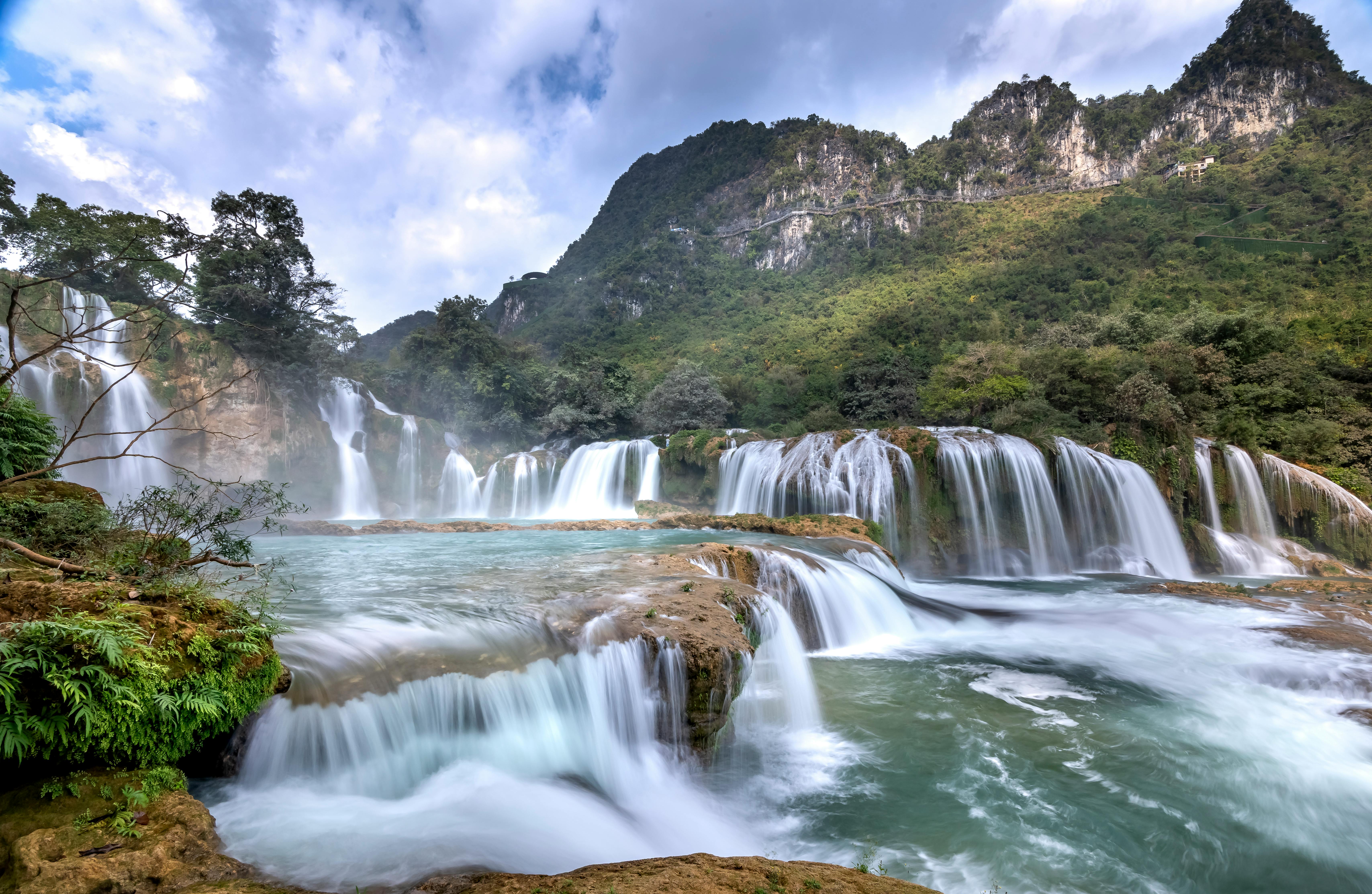
Ban Gioc sits directly on the Vietnam–China border — the main fall is shared between the two countries. The Vietnamese viewing area and bamboo raft access are entirely within Vietnam and require no special permits. Do not attempt to cross to the Chinese side, which is restricted. The border markers visible from the raft dock are one of the unusual details that make this waterfall different from any other — you are looking at the same water flowing over the same rock in two countries simultaneously.
Non Nuoc Cao Bang UNESCO Global Geopark
In 2018, UNESCO designated Non Nuoc Cao Bang as a Global Geopark — making it Vietnam's first. The designation covers approximately 3,000km² of the province and recognises the extraordinary geological heritage of the region: ancient limestone karst formations dating back 500 million years, fossil records from multiple geological periods, and an intact natural landscape that provides a readable history of the Earth's surface across hundreds of millions of years.
For the visitor, the geopark is not primarily a geological exhibition — it is a landscape of exceptional beauty whose dramatic character derives directly from its ancient geological history. The karst towers, deep river gorges, cave systems, and mountain passes of Cao Bang are the visible surface of 500 million years of formation. Understanding this adds a dimension to the scenery that turns a beautiful drive into something considerably more extraordinary.
Cau Son – Ban Thi Lakes: "Ha Long Bay in the Mountains"
The Cau Son – Ban Thi hydroelectric lake system in Bac Kan Province, on the southern approach to Cao Bang, is one of the most visually striking landscapes in northern Vietnam — and one of the least visited by international travellers. Created by the damming of the Nang River, the lake flooded a valley of extraordinary limestone karst formations, leaving hundreds of tower-karst islands rising from still emerald water.
Vietnamese travellers have nicknamed it "Ha Long Bay in the mountains" — the comparison is not entirely accurate (the scale is smaller and the setting is freshwater and forest rather than sea), but the emotional resonance is right: the same quality of karst-meets-still-water that makes Ha Long Bay extraordinary, experienced here in complete solitude. There are no cruise boats, no tourist infrastructure, and on a weekday morning in the low season, you may have the entire lake to yourself.

Cau Son is best visited as a stop on the Hanoi–Cao Bang route rather than a separate trip. It sits roughly midway between the two — approximately 130km from Hanoi and 140km from Cao Bang city. Small wooden boats can be hired from the lakeside jetty in Ban Thi village for a 1–2 hour circuit of the karst islands. There is basic accommodation in the village for those wishing to stay overnight, which is strongly recommended — the lake at dawn, with mist between the karst towers, is the highlight of the entire stop.
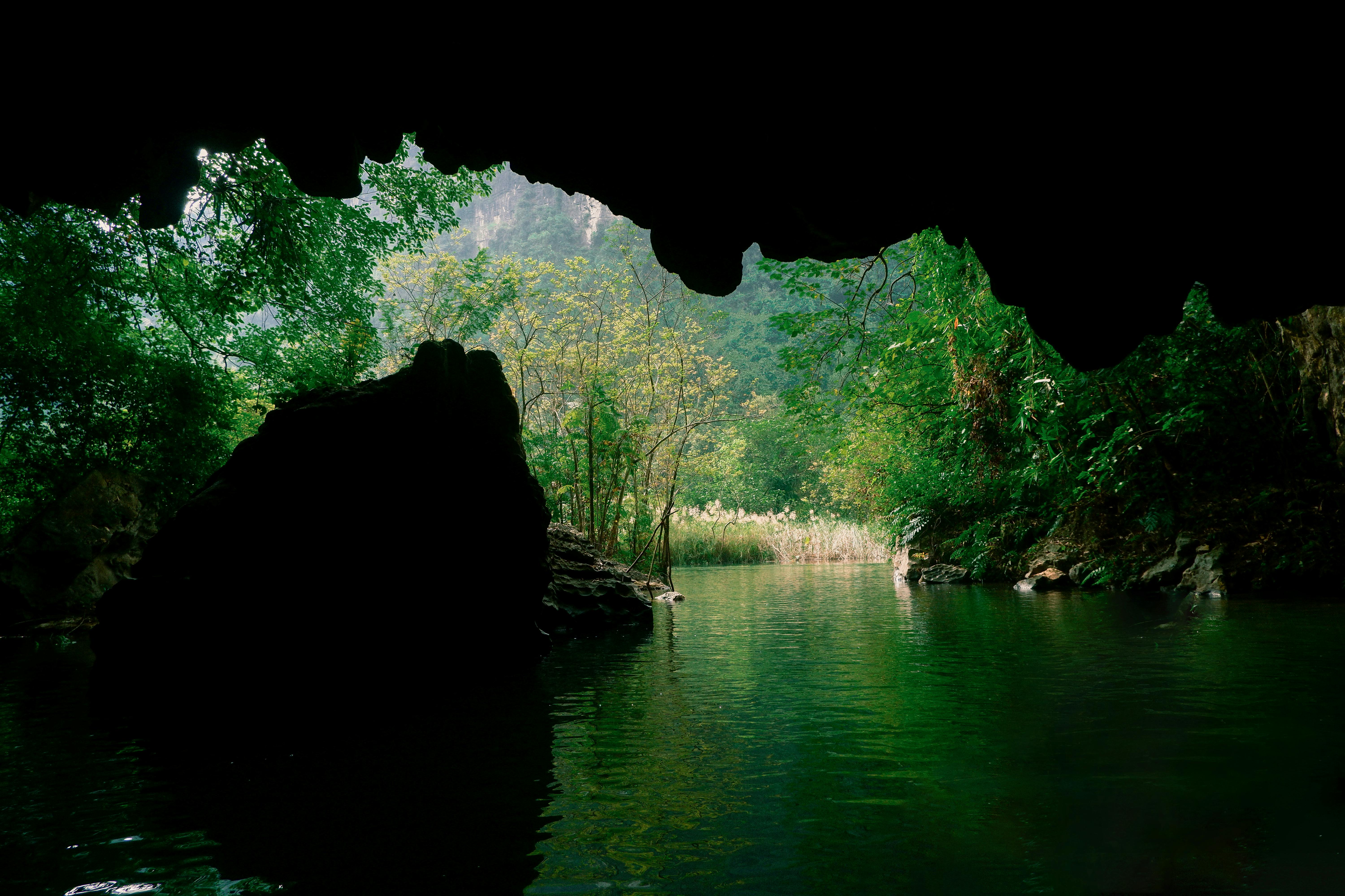
Nguom Ngao Cave — The Cave Next to Ban Gioc
Located just 3km from Ban Gioc Waterfall, Nguom Ngao (meaning "Tiger Cave" in the Tay language) is one of the most spectacular cave systems in Vietnam — and one of the most overlooked, simply because it sits in the shadow of its more famous neighbour. The cave stretches approximately 3km in total length, of which 948 metres is open to visitors on a guided circuit.
The interior is extraordinary: massive chambers with stalactites and stalagmites of unusual scale and variety, underground streams, and formations that have been developing for millions of years. The cave maintains a constant temperature of around 17°C year-round — noticeably cool in summer, almost warm in winter. The lighting system, while basic compared to more developed cave attractions, allows the natural formations to dominate rather than competing with dramatic coloured illumination. Allow 1.5–2 hours for the guided circuit.

Visit Ban Gioc Waterfall early (arrive by 07:00 for the morning light and the bamboo raft before the crowds), then walk or drive the 3km to Nguom Ngao Cave for the mid-morning visit when the cave's cool interior is a welcome contrast to the outdoor heat. The two together make a full and extremely satisfying morning — both are among the best experiences in the province and neither is overrun with tourists.
Pac Bo Cave — Where Ho Chi Minh Returned to Vietnam
In January 1941, after 30 years of exile working for Vietnamese independence from bases in China, France, the Soviet Union, and Thailand, Ho Chi Minh crossed back into Vietnam near the village of Pac Bo in Ha Quang District. He lived in the forest here for several months, using a small cave in the limestone karst as his base of operations, translating Marxist texts, writing poetry, and organising what would become the Viet Minh — the independence movement that, over the following decades, would defeat first France and then the United States.
The cave and its surroundings — named by Ho Chi Minh himself after Karl Marx (the stream running past the cave he called the Lenin Stream; the mountain above he called Karl Marx Peak) — are now a pilgrimage site of deep significance for Vietnamese people. For international visitors, the site offers something rare: a place where the abstract narrative of 20th-century Vietnamese history becomes concrete and human in scale. The cave is genuinely small, the stream genuinely cold, and the isolation of the place — the forest pressing in on all sides, the border with China invisible but close — gives an immediate sense of what it meant to be here in 1941, organising a revolution from a jungle cave.

| 🏔️ The cave itself — small, dark, and authentic. A simple stone platform marks where Ho Chi Minh slept and worked. The forest immediately around it is intact. |
| 🌊 Lenin Stream (Suoi Lenin) — a clear mountain stream where Ho Chi Minh reportedly fished for food. Extraordinarily peaceful and completely at odds with its historical significance. |
| 🗿 Karl Marx Peak (Nui Mac Lenin) — the forested mountain behind the cave, named by Ho Chi Minh. The climb takes 30–45 minutes and offers views across the border landscape. |
| 🏛️ Memorial site and museum — a small museum with photographs, documents, and artefacts from 1941 provides context. Vietnamese-language only, but a guide can translate the key exhibits. |
Pac Bo is located approximately 55km north of Cao Bang city in Ha Quang District, near the village of Truong Ha. It is best visited as a half-day excursion from Cao Bang city, either on the way to or from Ban Gioc Waterfall. The drive through the Ha Quang karst landscape to reach it is itself remarkable. A local guide is strongly recommended — both for navigating and for providing historical context that transforms the site from a scenic walk into something considerably more affecting.
Best Time to Visit Cao Bang
Getting to Cao Bang from Hanoi
Cao Bang is 270km from Hanoi via Highway 3 — approximately 5.5–6.5 hours by private car depending on stops. There is no direct train service, and the buses that serve the route are slow and not recommended for international visitors. The drive itself, however, is one of the most rewarding in northern Vietnam: the road climbs steadily through the Bac Can highlands, passes through the stunning Cau Son lake area, and arrives in Cao Bang through increasingly dramatic limestone karst landscape. Stop at least twice on the way.
| Day 1Hanoi → Cau Son lakes (lunch, boat ride, overnight) → Cao Bang city (arrive evening) |
| Day 2Cao Bang → Pac Bo Cave (morning) → Ban Gioc Waterfall (afternoon, bamboo raft, overnight near falls) |
| Day 3Ban Gioc early morning (dawn light) → Nguom Ngao Cave → return Hanoi via scenic route |
Practical Information for Visitors
Yes — Cao Bang is safe, and the local population is welcoming to foreign visitors. The main practical considerations are the remoteness (limited English signage outside Cao Bang city, few English-speaking locals, no tourist infrastructure comparable to Sapa or Ha Long Bay) and the frontier zone rules near the Chinese border. A private car and guide from Hanoi removes essentially all the complexity of independent travel here, and is the approach most international visitors use.
Yes — and it is one of the most rewarding northern Vietnam loops for experienced travellers. The route Hanoi → Cao Bang (Ban Gioc, Nguom Ngao, Pac Bo) → Ha Giang (Dong Van Karst Plateau, Ma Pi Leng Pass) → Hanoi can be done in 6–8 days by private car or motorbike. The two provinces complement each other well — Cao Bang for waterfalls, caves, and the border landscape; Ha Giang for the high mountain karst plateau and the extraordinary road scenery of the far north.
A genuinely interesting comparison. Ban Gioc is significantly smaller in volume than both Niagara and Iguazu. What it offers instead is a setting of extraordinary beauty that Niagara entirely lacks — the limestone karst backdrop, the rice paddies, the bamboo raft experience, the near-absence of crowds — and an intimacy that Iguazu's tourism infrastructure has largely removed. Travellers who have visited all three consistently describe Ban Gioc as the most moving experience, despite (or because of) its relative modesty in scale. It is not trying to compete with Niagara. It is doing something different entirely.
Planning a Vietnam Trip That Includes Cao Bang?
Cao Bang requires more planning than Sapa or Ha Long Bay — the right private driver, a local guide with minority village access, and overnight timing near Ban Gioc make the difference between a good trip and an extraordinary one. We can arrange all of it.
| Plan My Cao Bang Trip → | View All Tours → |
0 Comment